ST3400H HeliTAWS® Terrain Awareness & Warning System

ST3400H HeliTAWS® Terrain Awareness & Warning System

The ST3400H HeliTAWS® Helicopter Terrain Awareness and Warning System is certified and exceeds the current HTAWS TSO-C194. Specifically built for helicopters, the ST3400H combines an advanced HTAWS computer with the industry’s best display technology to provide a single panel-mount, self-contained solution. Combining its TAWS expertise from thousands of installations in private, corporate and air-transport airplanes and years of supplying civilian and military users with its 3” and 4” primary displays, Nighthawk Flight Systems provides the helicopter industry a multi-hazard avoidance system that alerts against wires, terrain and obstacles.

Product Images

Operational Benefits & Other Details

  • Tested to DO-160F helicopter vibration standards, HeliTAWS is built for reliability.
  • Engineering based on the industry standard ST3400 Part 25 Class-A TAWS.
  • Exceeds TSO C194 (HTAWS) standards.
  • WireWatch® & TruAlert®
  • Self-contained 3-ATI size allows the ST3400H to be installed in the place of an existing radar altimeter indicator, giving you two in one.
  • Displays ultra-high resolution terrain, clearly identifiable obstacles and GPS flight plan.
  • TSO’d traffic indicator when interfaced to an existing TAS/TCAD/TCAS processor or compatible ADS-B In transponder.
  • Integral Minimums (MINS) knob with aural and discrete outputs.
  • Best display performance – uses 3ATI LED backlit display engine.
  • >10,000 Hour MTBF.


WireWatch®

Advance defense against wire strikes that helps helicopter pilots avoid transmission lines whether they are powered on or off. WireWatch uses unique wire alerting algorithms that work proprietary 3-arc second wire database.

TruAlert®
TruAlert is our proprietary alerting technology that enables pilots to take off, cruise, hover and land at off-airport locations without triggering nuisance alerts.

NVIS Option
For missions flown under night vision goggles, the HeliTAWS® can be ordered with proprietary on-demand Class-B NVIS option. Unlike aftermarket NVIS modifications, our unique NVIS mode employs no external filters and does not degrade its brightness or daylight characteristics when NVIS is ‘off’.

GPWS Modes
For those requiring additional capability the HeliTAWS supports GPWS Modes 1, 3, 4, 5 and 6.

Offshore Modes
RTCA/DO-376 Offshore HTAWS modes 1, 3A, 3B, 4A, 4B and 5.

Product Support

ST3400H Software Version History


Note: Software versions denoted with ‘A’ are applicable only to Mod A hardware (serial numbers 46-2200 and higher).

A1.07 – Released 10/13/2016
  • ​Accommodates non-standard GPS ground track format from Garmin non-WAAS GPS receivers
1.06 – Released 10/13/2016
  • Accommodates non-standard GPS ground track format from Garmin non-WAAS GPS receivers.
A1.06 – Released 8/21/2015
  • Added support for analog interface with APN-209 radar altimeter.
A1.05 – Released 10/2/2014
  • Same features as 1.05 below.
1.05 – Released 9/5/2014
  • New HIGH SENS mode which provides a larger area of alert protection and is intended for IFR operations
  • Ability to selectively enable/disable all sensitivity modes (other than NORMAL) during installation configuration
  • Alternate Mode-1 curve for customers requiring compliance with Russian certification requirements (requires purchase of key code)
  • 400 foot callout – used in HIGH SENS mode only
  • Added interface capability with Sandia SAC 7-35 ADC
  • Garmin GTN 6XX/7XX added to selection menu
  • Improved database update transfer speed
A1.04 – Released 1/15/2014
  • Support for Mod A hardware.
1.03 – Released 10/4/2011
  • Wire (Power Transmission Line) alerting in regions with available data.
  • Change to TAWS Inhibit mode. The display will no longer be grayed out after pressing TAWS Inhibit. TOPO and REL displays will continue to present terrain and obstacle data. Audio and visual TAWS alerts will be suppressed.
  • Activation of TAWS Inhibit changed to press and hold of the MUTE button.
  • Fixes a problem with terrain data sometimes appearing gray as if outside the coverage area.
  • Two new sensitivity modes have been added: ‘Tactical’ and ‘Obstacle Only’ allowing for operations lower and closer to terrain without nuisance alerting.
  • Field offload of recorded data for maintenance support.
  • MINS annunciation and discrete outputs assert when pressing Radalt Test.
  • Water bodies (lakes and rivers) added.
  • OVLY button has been activated, allowing depiction of major highways.
  • Altitude callouts will be independent of landing gear configuration.
1.01 – Released 9/10/2010
  • Commercial Release.

TAWS Products (ST3400)


The ST3400 TAWS database is updated 3-4 times a year. Please contact Nighthawk Flight Systems to purchase a database update.

The database consists of two files, an airport file and a terrain/obstacle file, both of which are updated through the USB interface.

ST3400 Database Update Instructions (1.8 MB)

Current Database Version


Airport Listing – ST3400 December 2021 Database (6 MB)

Airport Database: Cycle 2501 Effective JAN 23, 2025

Terrain/Obstacle Databases Merged:

Obstacle: 01JAN25 (2025Q1)

Terrain: 30NOV18

Database Regions


The following coverage regions are available for the ST3400.

Note: The worldwide region is only supported by ST3400 units with serial numbers 2000 or higher.

North America Region


Africa Region


Asia Pacific Region


Europe Region

Globe Region


South America

HeliTAWS Products (ST3400H and ST3453H)


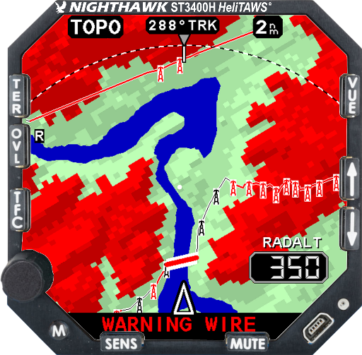
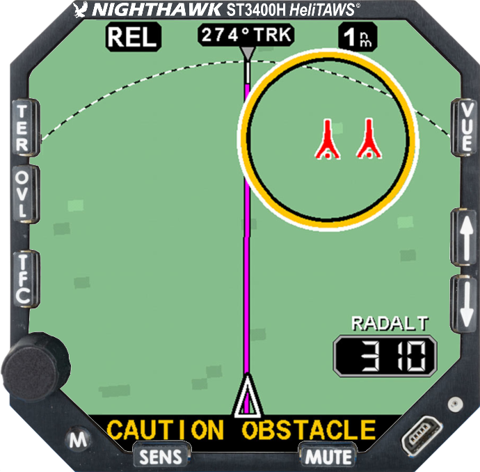
The HeliTAWS database consists of four files for the following datasets: airports, geographic overlay (water bodies and roads), obstacles, and terrain.

Current database revision dates as shown during startup:

Terrain Revision: 30NOV18

Obstacle Revision:01JAN25 (2025Q1)

Airport Revision: Effective JAN 23, 2025, Cycle 2501

Overlay Revision: 01JAN13

Database updates are available on a yearly subscription basis. Please contact Nighthawk Flight Systems to order and download an update.

WIREWATCH® Transmission Line Coverage Information


Currently, transmission line data is available the United States, Canada and New Zealand. This data is updated as part of the obstacle database file.

HeliTAWS Transmission Line Coverage – USA and Canada (721 kB)


ST3400H Service Bulletins and Service Information Letters


SB 3400H-08: Software Versions A1.07 and 1.06 – 10/13/2016
SB 3400H-07: Obstacle Database – 02/03/2016
SIL 3400H-06: Software version A1.06 – 8/27/2015
SIL 3400H-05: Software version 1.05 and A1.05 – 9/26/2014 (Revised)
SIL 3400H-03: Software version 1.03 – 10/4/2011
SIL 3400H-01: Installations with analog air data sensor – 12/13/2010

ST3400H Software Update Access